WFU launches online interactive map
 Wake Forest has launched a new online interactive map in order to bring the University’s campus to life for those wanting to explore it virtually.
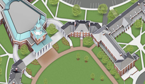
The new map (available at map.wfu.edu) is built on top of Google Maps and includes 3D models, 2D graphic overlays, photos and is mobile friendly. It covers the Reynolda Campus, including facilities along Reynolds Boulevard, as well as Reynolda House, Reynolda Gardens and Graylyn. The University’s digital communication team in Communications and External Relations (CER) teamed with concept3D and their Campus Bird platform for the project.
The map will be enhanced during spring of 2015 with videos, audio, 360-degree photos and virtual tours. The University now can edit the map to reflect changes on campus.
“The new map allows us to present Wake Forest’s beautiful campus in a much richer way,” said Mark Anderson, director of digital communication. “We believe it will be compelling to prospective students and their families, as well as others who are not able to see campus in person, while also being functional for those visiting.”
The map also presents information in layers, which allows Wake Forest to continue to add detail. The user can activate layers, allowing the map to display only the information the user really needs.
Lloyd Whitehead, user experience designer for CER, led the map project and worked with Google to improve the Google Earth experiences around Wake Forest. Google came to Wake Forest and reshot all of its street-view imagery by car. Whitehead also worked with Google to walk all of the Wake Forest property, and Google will soon add Wake Forest as one of about 30 U.S. universities with full campus street-view tours.
If you have feedback or suggestions regarding the new map, please email .
Categories: University Announcements